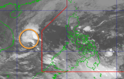

The state weather bureau is closely monitoring a low-pressure area (LPA), which may develop into the first storm to hit the country this year.
The Philippine Atmospheric, Geophysical and Astronomical Services Administration (PAGASA) reported as early as 2 AM on February 12 that an LPA detected just beyond the Philippine Area of Responsibility (PAR) has a “medium” chance of intensifying into a tropical depression within the next 24 hours.
The storm, upon entering the PAR, will be called Auring.
PAGASA's previous forecast was that one storm at most, and possibly none, would strike the country this month. However, the shearline and northeast monsoon, known as “amihan,” will bring rain to many parts of the Philippines.
According to a report on Magandang Umaga Pilipinas, the shearline, occurring where warm and cool air meet, will affect Metro Manila, Aurora, CALABARZON, Camarines Norte, Camarines Sur, Marinduque, and Oriental Mindoro.
The easterlies will pull in scattered rains over the Davao region, SOCCSKSARGEN, while the LPA trough will affect the province of Palawan.
Due to the amihan, skies over Cagayan Valley and the Cordillera Administrative Region (CAR) will remain cloudy, which may lead to scattered rainfall.
The agency advised the public to keep an eye out for updates on the weather.