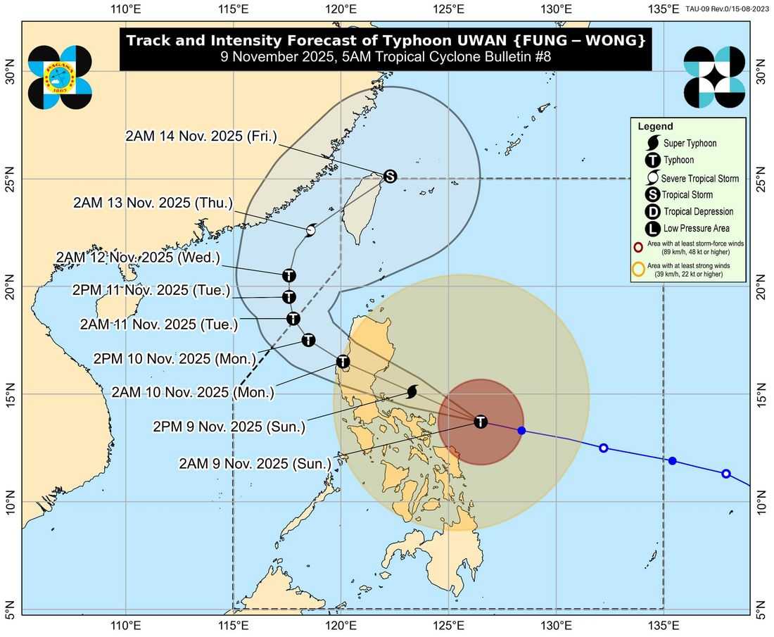
Typhoon Uwan (international name: Fung-Wong) continues to rapidly intensify as it moves closer to Catanduanes, according to PAGASA’s 5:00 AM tropical cyclone bulletin.
As of 4:00 AM, the eye of Typhoon Uwan was located 195 kilometers east of Virac, Catanduanes with maximum sustained winds of 175 km/h, gustiness of up to 215 km/h, and a central pressure of 940 hPa. The typhoon is moving west-northwest at 35 km/h, with strong to typhoon-force winds extending up to 800 kilometers from its center.
Areas Under Tropical Cyclone Wind Signals
Signal No. 4
-
Polillo Islands
-
Eastern and central Camarines Norte
-
Eastern Camarines Sur
-
Catanduanes
-
Eastern Albay
Signal No. 3
-
Isabela, Quirino, Nueva Vizcaya, Kalinga, Mountain Province, Ifugao, Benguet, La Union, Pangasinan, Metro Manila, Bulacan, Pampanga, Tarlac, Nueva Ecija, Aurora, Cavite, Laguna, Rizal, Batangas (east), Quezon, Camarines Norte, Camarines Sur, Albay, Sorsogon, Burias and Ticao Islands, and parts of Northern Samar, Eastern Samar, and Samar.
Signal No. 2
- Cagayan, Apayao, Abra, Ilocos Region, Mindoro provinces, Romblon, Masbate, Marinduque, and portions of the Visayas and Northern Mindanao.
Signal No. 1
- Batanes, Palawan including Calamian and Cuyo Islands, and several areas in Visayas and Mindanao.
PAGASA warned that Significant to severe wind impacts are possible in areas under Signal No. 4.
Storm surges exceeding 3 meters may affect coastal areas in Cagayan, Isabela, Aurora, Quezon, Bicol Region, Metro Manila, and parts of Samar, Northern Samar, and Surigao provinces within 48 hours.
A Gale Warning remains in effect over the seaboards of Luzon, Visayas, and Mindanao, with sea waves reaching up to 14 meters in the Bicol region and eastern seaboards. All sea travel remains risky for all types of vessels.
Forecast Track
Typhoon Uwan is expected to pass close to Catanduanes this morning and make landfall over Aurora late tonight or early Monday morning.
PAGASA added that Uwan may reach super typhoon category before landfall and will weaken as it crosses Northern Luzon.
After passing over land, the typhoon is forecast to emerge over the Lingayen Gulf or the coastal waters of Pangasinan or La Union by Monday morning.
Authorities urge residents in high-risk areas to prepare for strong winds, heavy rains, and storm surges, and to follow evacuation orders and updates from local officials and disaster management offices.