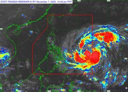
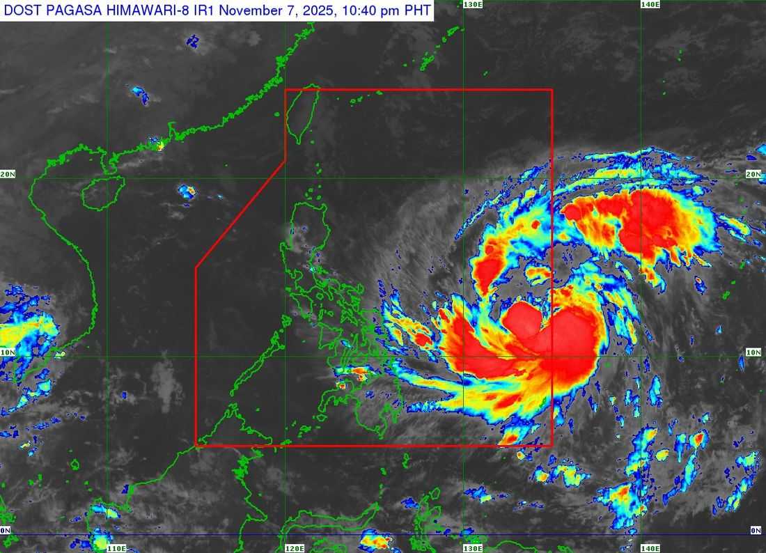
The anticipated strong typhoon has entered the Philippine Area of Responsibility on Friday night, according to PAGASA.
As of 10 PM, the center of Typhoon Uwan was last located at 10:00 PM, approximately 1,045 kilometers east of Eastern Visayas (12.3°N, 135.0°E). It carries maximum sustained winds of 120 kilometers per hour (km/h) near the center, gustiness of up to 150 km/h, and is moving west-northwestward at 20 km/h.
According to PAGASA, the extent of Uwan’s strong to typhoon-force winds has expanded, now reaching up to 780 kilometers from the center.
Areas under Tropical Cyclone Wind Signal (TCWS) No. 1
Luzon
-
Isabela (eastern portion): Divilacan, Palanan, Dinapigue, San Mariano, San Guillermo, Echague, Jones, San Agustin
-
Quirino (eastern and southern portions): Maddela, Nagtipunan
-
Nueva Vizcaya (southeastern portion): Alfonso Castañeda
-
Aurora
-
Rizal (southeastern portion): Tanay, Pililla, Jala-Jala
-
Laguna (eastern portion): Luisiana, Mabitac, Liliw, Majayjay, Paete, Pagsanjan, Rizal, Pangil, Santa Maria, Siniloan, Nagcarlan, Cavinti, Kalayaan, Lumban, Magdalena, Victoria, Pakil, Santa Cruz, Pila, Famy
-
Quezon (eastern and southern portions): Tagkawayan, Guinayangan, Calauag, Lopez, Buenavista, Catanauan, Mulanay, San Narciso, San Andres, San Francisco, Pitogo, Lucena City, Pagbilao, Infanta, Unisan, General Luna, Plaridel, Quezon, Alabat, Lucban, Sampaloc, Padre Burgos, City of Tayabas, Macalelon, Mauban, General Nakar, Perez, Agdangan, Gumaca, Atimonan, Real, Sariaya, Candelaria
-
Including Polillo Islands
-
-
Romblon
-
Marinduque
-
Bicol Region: Camarines Norte, Camarines Sur, Albay, Catanduanes, Sorsogon, Masbate (including Ticao and Burias Islands)
Visayas
-
Northern Samar
-
Eastern Samar
-
Samar
-
Biliran
-
Leyte
-
Southern Leyte
-
Cebu (northern and central portions): Medellin, Daanbantayan, City of Bogo, Tabogon, San Remigio, Tabuelan, Borbon, Sogod, Tuburan, Catmon, Carmen, Danao City, Compostela, Liloan, Consolacion, Lapu-Lapu City, Mandaue City, Cordova, Asturias, Cebu City, Balamban, City of Talisay, Toledo City, Minglanilla
-
Including Bantayan and Camotes Islands
-
-
Bohol (northeastern portion): Getafe, Talibon, Buenavista, Trinidad, San Miguel, Ubay, Alicia, Mabini, Bien Unido, Pres. Carlos P. Garcia
-
Negros Occidental (northern portion): City of Escalante, Toboso, Sagay City, Cadiz City, Calatrava, Manapla, City of Victorias, Enrique B. Magalona, Silay City, City of Talisay
-
Iloilo (northern portion): Carles, Estancia, Balasan, San Dionisio, Concepcion, Batad, Sara, Ajuy, Barotac Viejo, San Rafael, Lemery
-
Capiz (northeastern and western portions): President Roxas, Pilar, Panay, Pontevedra, Ma-ayon, Cuartero, Dumarao, Dao, Panitan, Roxas City, Ivisan, Sigma, Sapian, Mambusao, Dumalag, Jamindan
-
Aklan
Mindanao
-
Dinagat Islands
-
Surigao del Norte
Based on the track forecast, Uwan is expected to make landfall over the southern portion of Isabela or the northern portion of Aurora between Sunday evening (November 9) and early Monday morning (November 10).
After landfall, the typhoon will cross the mountainous terrain of Northern Luzon before exiting into the West Philippine Sea by Monday morning or afternoon.
PAGASA added that Uwan may intensify into a super typhoon by Saturday evening or Sunday morning as it moves closer to land.
Warnings for Heavy Rain, Strong Winds, and Storm Surge
PAGASA also warned of heavy rainfall and dangerous storm surges that may reach 3 meters or higher, particularly over the low-lying coastal areas of Quezon (including the Polillo Islands), Camarines Norte, Camarines Sur, Catanduanes, Albay, and Sorsogon.
A gale warning is in effect over the eastern seaboards of Southern Luzon and Visayas, where sea travel remains risky due to very rough seas reaching up to 5 meters.
PAGASA advises fisherfolk and small sea vessels to avoid venturing out to sea while strong winds and high waves continue to prevail over the eastern sections of the country.