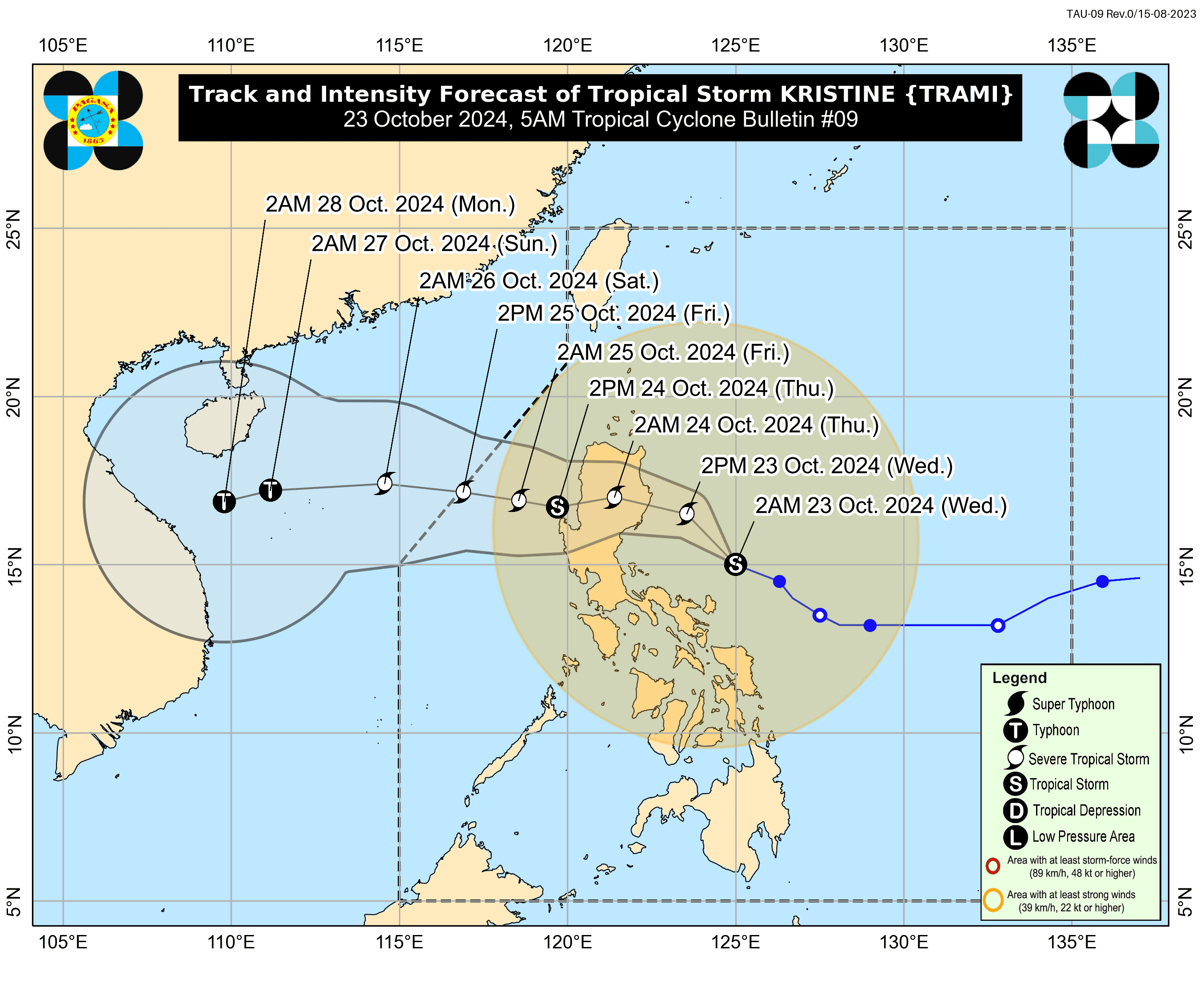

Tropical Storm "Kristine" has slightly intensified while moving over the sea east of Quezon. The storm is forecast to bring heavy rainfall, severe winds, and coastal hazards, prompting PAGASA to issue warnings across Luzon, Visayas, and Mindanao.
According to the latest advisory from PAGASA, the eye of Kristine is located 180 km north-northeast of Virac, Catanduanes, moving west-northwestward at 25 km/h with maximum sustained winds of 85 km/h near the center and gusts of up to 105 km/h.
As a result, Tropical Cyclone Wind Signal (TCWS) No. 2 has been hoisted in the following areas in Luzon:
Luzon
- Ilocos Norte
- Ilocos Sur
- La Union
- Pangasinan
- Apayao
- Abra
- Kalinga
- Mountain Province
- Ifugao, Benguet
- mainland Cagayan
- Isabela, Quirino
- Nueva Vizcaya
- Aurora
- Nueva Ecija
- Tarlac
- The northern portion of Zambales (Santa Cruz, Candelaria, Masinloc, Palauig)
- The northern portion of Bulacan (Doña Remedios Trinidad, San Miguel, San Ildefonso)
- The northern portion of Quezon (General Nakar, Infanta)
- Polillo Islands
- Camarines Norte
- The northern and eastern portions of Camarines Sur (Calabanga, Goa, Tigaon, Saglay, San Jose, Lagonoy, Tinambac, Siruma, Garchitorena, Presentacion, Caramoan)
- Catanduanes
- The eastern portion of Albay (Rapu-Rapu, Bacacay, City of Tabaco, Malilipot, Malinao, Tiwi, Manito, Santo Domingo)
- The eastern portion of Sorsogon (Barcelona, Gubat, Prieto Diaz, City of Sorsogon)
Visayas
- The northeastern portion of Northern Samar (Palapag, Mapanas, Gamay, Laoang, Catubig, Lapinig, Pambujan, San Roque)
- The northern portion of Eastern Samar (Jipapad, San Policarpo, Arteche)
Meanwhile, TCWS No. 1 has been raised over the following areas:
Luzon
- Batanes
- Babuyan Islands
- Pampanga
- the rest of Zambales
- Bataan
- The rest of Bulacan
- Metro Manila
- Rizal
- Cavite
- Laguna
- Batangas
- The rest of Quezon
- Occidental Mindoro
- Lubang Islands
- Oriental Mindoro
- Marinduque
- Romblon
- Calamian Islands
- The rest of Camarines Sur
- Albay
- Sorsogon
- Masbat
- Ticao and Burias Islands
Visayas
- Aklan
- Capiz
- Antique
- Iloilo
- Guimaras
- northern Negros Occidel
- Central and Northern Cebu including Bantayan and Camotes Islands, Bohol, Eastern Samar, Northern Samar, Samar, Leyte, Biliran, and Southern Leyte.
Mindanao
- Dinagat Islands
- Surigao del Norte including Siargao-Bucas Grande Islands.
Residents in these areas should prepare for potential impacts and stay updated on the latest weather advisories from PAGASA.
According to the weather bureau, the highest possible wind signal during the storm is Wind Signal No. 3.
Coastal Inundation and Storm Surge Warning
PAGASA has issued Storm Surge Warning No. 4, highlighting a moderate to significant risk of life-threatening storm surges in the next 48 hours for low-lying coastal areas of Ilocos Norte, Ilocos Sur, La Union, Pangasinan, Cagayan, Isabela, Zambales, Aurora, and Catanduanes. Residents in these areas are strongly advised to evacuate or seek higher ground.
Sea Conditions and Gale Warnings
A Gale Warning has been issued for the seaboards of Luzon and Visayas, with sea conditions expected to be hazardous for all types of vessels:
- Up to 8 meters: Seaboards of Batanes, Cagayan including Babuyan Islands, Ilocos Norte, and Ilocos Sur.
- Up to 7 meters: Seaboards of La Union, Pangasinan, Isabela, Northern Aurora, Camarines Norte, Catanduanes, and the northern and eastern seaboards of Camarines Sur.
- Up to 6 meters: Seaboards of Aurora, Quezon (including Polillo Islands), and Northern Samar.
Sea travel remains extremely dangerous. Mariners are advised to remain in port or, if at sea, seek shelter immediately.
Rough Seas and High-Risk Areas
Rough sea conditions will persist in coastal waters, with waves reaching up to 5 meters along the seaboards of Bataan, Batangas, Occidental Mindoro, Oriental Mindoro, Romblon, Marinduque, and the Visayas. Even smaller seacrafts, including motorbancas, are urged to avoid sailing under these dangerous conditions.
The storm is projected to make landfall over Isabela or northern Aurora this evening or early tomorrow (24 October). It will cross the mountainous terrain of Northern Luzon and re-emerge over the West Philippine Sea by tomorrow afternoon.
While "Kristine" is expected to gradually intensify into a severe tropical storm before making landfall, slight weakening may occur as it passes over Northern Luzon. However, re-intensification is possible once it reaches the West Philippine Sea.
The storm may exit the Philippine Area of Responsibility (PAR) by Friday, 25 October.
