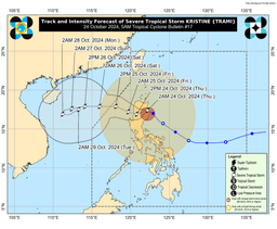

Severe Tropical Storm Kristine gradually decelerated while moving northwestward over Northern Luzon, PAGASA reported on Thursday, October 24.
As of 5:00 AM, the storm continued to pose significant threats to affected areas, with Wind Signal No. 3 still hoisted over 16 provinces.
The center of Kristine was located in the vicinity of Tumauini, Isabela, moving west-northwestward at 15 km/h, with maximum sustained winds of 95 km/h near the center and gusts of up to 160 km/h.
Tropical Cyclone Warning Signal (TCWS) No. 3 remained raised in the following areas:
- The southern portion of Cagayan (Peñablanca, Tuguegarao City, Enrile, Solana, Iguig, Tuao)
- Isabela
- Quirino
- Nueva Vizcaya
- Kalinga
- Mountain Province
- Ifugao
- Southern portion of Abra (Malibcong, Licuan-Baay, Sallapadan, Daguioman, Bucloc, Boliney, Tubo, Luba, Manabo, Bucay, Villaviciosa, Pilar, San Isidro, Peñarrubia)
- Benguet
- Northern and central portions of Aurora (Dilasag, Casiguran, Dinalungan, Dipaculao, Maria Aurora, Baler)
- Northern portion of Nueva Ecija (Carranglan, Lupao, San Jose City, Pantabangan, Guimba, Santo Domingo, Talavera, Llanera, Rizal, Bongabon, Talugtug, Science City of Muñoz, Cuyapo, Nampicuan)
- Northern portion of Tarlac (Mayantoc, San Clemente, Camiling, Santa Ignacia, Gerona, Paniqui, Moncada, San Manuel, Anao, Ramos, Pura, Victoria)
- Northern portion of Zambales (Candelaria, Santa Cruz, Masinloc)
- Pangasinan
- La Union
- Central and southern portions of Ilocos Sur (Cervantes, Quirino, Sigay, Suyo, Alilem, Sugpon, Tagudin, Santa Cruz, Salcedo, Gregorio del Pilar, San Emilio, Lidlidda, Burgos, San Esteban, Santiago, Banayoyo, Galimuyod, City of Candon, Santa Lucia, Nagbukel, Santa Maria, Narvacan)
Meanwhile, TCWS no. 2 is hoisted in the following areas:
- Ilocos Norte
- The rest of Ilocos Sur
- Apayao
- The rest of Abra
- The rest of Cagayan
- Babuyan Islands,
- The rest of Aurora
- The rest of Nueva Ecija
- Bulacan
- The rest of Tarlac
- Pampanga
- The rest of Zambales
- Bataan
- Metro Manila
- Cavite
- Laguna
- Rizal
- Batangas
- The northern and central portions of Quezon (Lucena City, Pagbilao, Infanta, Tiaong, San Antonio, Candelaria, Lucban, Sampaloc, Sariaya, City of Tayabas, Mauban, Dolores, General Nakar, Real)
- Polillo Islands
- Lubang Island
TCWS No.1 remains over the following areas:
Luzon
- Batanes
- The rest of Quezon
- The rest of Occidental Mindoro
- Oriental Mindoro
- Marinduque
- Romblon
- The northern portion of mainland Palawan (El Nido, Taytay, Araceli, San Vicente, Dumaran, Roxas)
- Calamian Islands
- Cuyo Islands
- Camarines Norte
- Camarines Sur
- Catanduanes
- Albay
- Sorsogon
- Masbate
- Ticao and Burias Islands
Visayas
- Aklan
- Capiz
- Antique including Caluya Islands
- Iloilo
- Guimaras
- The northern portion of Negros Occidental (Pulupandan, Bacolod City, Silay City, City of Talisay, Enrique B. Magalona, Manapla, City of Victorias, Cadiz City, Sagay City, City of Escalante, Toboso, Valladolid, Bago City, Murcia, Salvador Benedicto, Calatrava)
- The northern portion of Cebu (Medellin, Daanbantayan, San Remigio, City of Bogo, Tabuelan, Tabogon) including Bantayan Islands
- Northern Samar
- Samar
- Biliran
- The northern portion of Eastern Samar (Oras, Can-Avid, Maslog, San Policarpo, Taft, Dolores, Jipapad, Arteche, Sulat)
- The northern portion of Leyte (San Isidro, Calubian, San Miguel, Babatngon, Barugo, Tunga, Carigara, Capoocan, Leyte, Villaba, Tabango)
Heavy Rainfall and Wind Impact
The storm is expected to bring moderate to heavy rainfall in several parts of the country, as outlined in PAGASA's Weather Advisory No. 18. Severe winds remain a concern, especially for areas under Wind Signal No. 3, where moderate to significant impacts from storm-force winds are expected.
In areas under Wind Signal No. 2, gale-force winds could lead to minor to moderate damage. For localities under Wind Signal No. 1, minimal impacts from strong winds are anticipated.
Coastal and upland areas, particularly in the regions of MIMAROPA, Bicol, and parts of Visayas and Mindanao, are also bracing for strong gusts of wind as the Northeasterly Windflow adds to the severity of Kristine’s winds.
Coastal Inundation and Storm Surge Risks
A moderate to high risk of life-threatening storm surges—up to 3.0 meters above normal tide levels—persists in low-lying coastal localities. Provinces such as Ilocos Norte, Ilocos Sur, La Union, Pangasinan, Cagayan, Isabela, Aurora, Zambales, and Quezon are under particular threat, with the potential for severe coastal flooding.
Residents are urged to stay vigilant and refer to the latest Storm Surge Warning issued by PAGASA for further details.
Hazardous Sea Conditions
The gale warning issued over the seaboards of Luzon and Visayas remains in effect, with very rough to high seas expected. Waves could reach up to 8.0 meters in the coastal waters of Cagayan Valley, Ilocos Region, and Zambales, posing significant risks to sea travel. Mariners of all vessel sizes, especially small seacrafts, are advised to remain in port or seek shelter until conditions improve.
Sea conditions remain dangerous across various coastal areas, with moderate to rough seas affecting parts of MIMAROPA, the western seaboards of Quezon and Negros Oriental, and other islands such as Camiguin and Dinagat.
Track and Intensity Outlook
Kristine is forecast to cross Northern Luzon over the next 12 hours before emerging over the waters west of Ilocos Region later this afternoon or evening. Although slight weakening is expected due to land interaction, Kristine may regain strength as it re-enters the West Philippine Sea.
The tropical cyclone is expected to exit the Philippine Area of Responsibility (PAR) by tomorrow afternoon, October 25.
