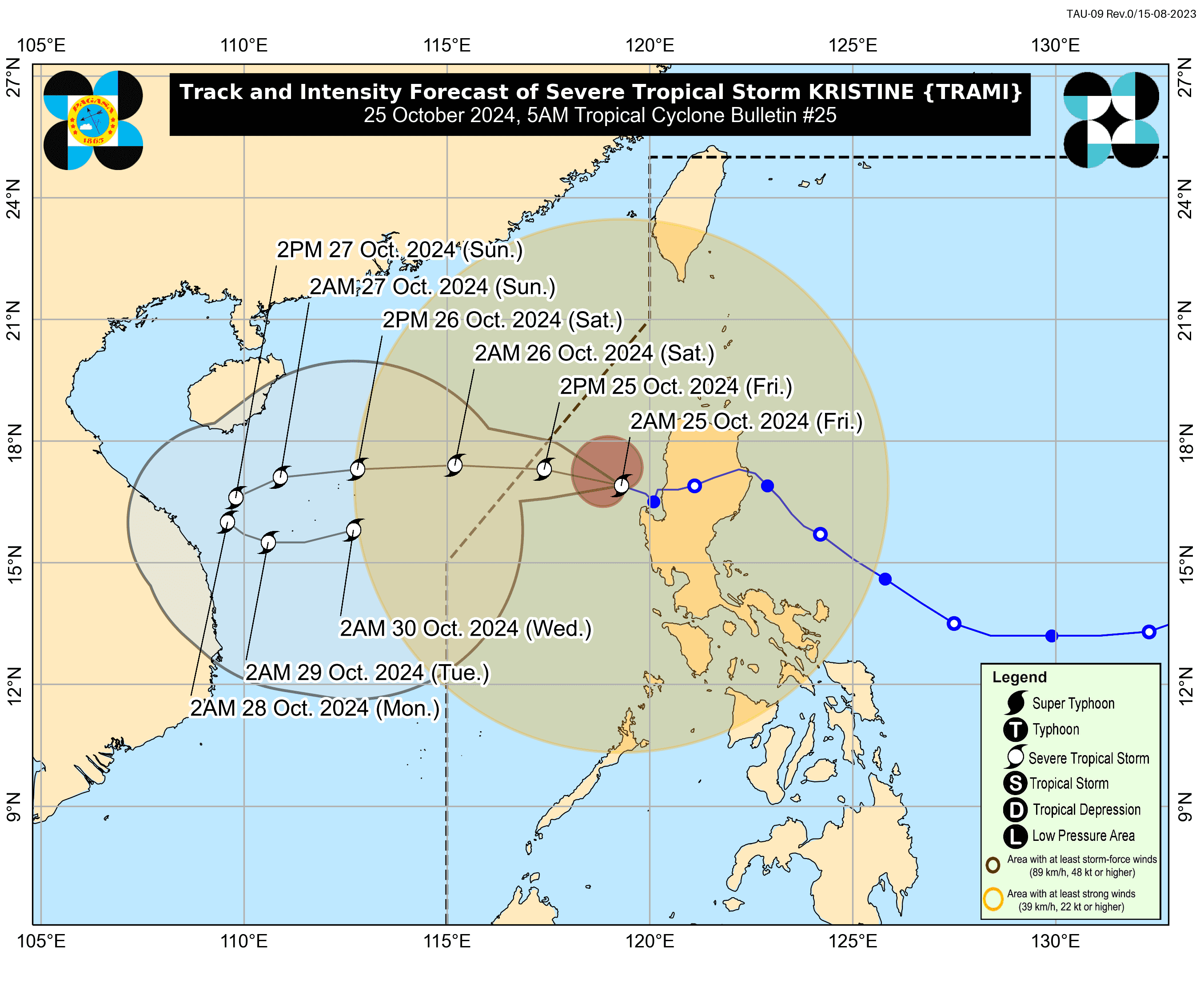
Severe Tropical Storm Kristine continues to maintain its strength as it moves west northwestward over the sea west of Northern Luzon on Friday, October 25.
As of PAGASA's 5 a.m. advisory, Kristine's eye is located approximately 125 km west northwest of Bacnotan, La Union, with maximum sustained winds of 95 km/h near the center and gusts of up to 115 km/h.
Tropical Cyclone Wind Signal No. 2 remains in effect for several areas such as the following:
- Cagayan (including Babuyan Islands)
- Isabela
- Quirino
- Nueva Vizcaya
- Apayao
- Kalinga
- Abra
- Ifugao
- Mountain Province
- Benguet
- Ilocos Norte
- Ilocos Sur
- La Union
- Pangasinan
- Aurora
- Nueva Ecija
- Tarlac
- Zambales
- Bataan
- Pampanga
- Bulacan
- Metro Manila
- Northern Cavite (including Ternate, Maragondon, Naic, Tanza, City of General Trias, Rosario, Cavite City, Noveleta, Kawit, Imus City, Bacoor City)
- Northern Rizal (including Cainta, Taytay, Angono, San Mateo, Rodriguez, Tanay, City of Antipolo, Baras, Teresa, Morong)
- Northern Mainland Quezon (General Nakar)
Meanwhile, TCWS no. 1 are still hoisted in the following areas:
Luzon
- Batanes
- The rest of Rizal
- The rest of Cavite
- Batangas
- Laguna
- The rest of Quezon (including Polillo Islands)
- Occidental Mindoro (including Lubang Islands)
- Oriental Mindoro
- Marinduque
- Romblon
- Northern Portion of Mainland Palawan (including El Nido, Taytay, Araceli, Dumaran, San Vicente)
- Calamian, Cuyo
- Kalayaan Islands
- Camarines Norte
- Camarines Sur
- Catanduanes
- Albay
- Northern and Central Portions of Sorsogon (including Castilla, Magallanes, Pilar, Casiguran, Donsol, Juban, Gubat, City of Sorsogon, Prieto Diaz, Bulan)
- Northern and Central Portions of Masbate (including City of Masbate, Uson, Dimasalang, Mobo, Cawayan, Aroroy, Balud, Mandaon, Milagros, Baleno) (including Ticao and Burias Islands)
Visayas
- Aklan
- Capiz
- Antique (including Caluya Islands)
- Iloilo
- Bantayan Islands
- Western Portion of Northern Samar (including Rosario, Biri, San Isidro, Capul, San Vicente, Victoria, Lavezares, San Antonio, San Jose, Allen, Bobon)
- Northern Portion of Samar (Tagapul-An)
Local winds may be slightly enhanced in coastal and upland areas. Areas under Wind Signal No. 2 may experience minor to moderate impacts from gale-force winds, while regions under Wind Signal No. 1 may face minimal to minor impacts.
The following areas are expected to experience strong to gale-force gusts:
- Today (October 25): MIMAROPA, Bicol Region, Visayas, Dinagat Islands, Surigao del Norte, Northern Mindanao, Zamboanga Peninsula, BARMM, SOCCSKARGEN, and Davao Region.
- Tomorrow (October 26): Palawan, Siquijor, Bohol, Southern Leyte, Zamboanga del Norte, Camiguin, Dinagat Islands, and Surigao del Norte.
- Sunday (October 27): Palawan, Romblon, Visayas, Siquijor, Bohol, Southern Leyte, Zamboanga del Norte, Camiguin, Dinagat Islands, and Surigao del Norte.
Coastal Inundation Risks
A Storm Surge Warning has been issued, indicating a minimal to moderate risk of storm surge with peak heights of 1.0 to 2.0 meters above normal tide levels in low-lying or exposed coastal areas of Ilocos Sur, La Union, Pangasinan, and Zambales.
Gale Warnings and Sea Conditions
A Gale Warning is currently in effect for the seaboards of Luzon and the western seaboard of Visayas. The 24-hour sea condition outlook indicates very rough to high seas:
- Up to 7.0 meters: Seaboards of Zambales and Pangasinan
- Up to 5.5 meters: Remaining seaboard of Ilocos Region, seaboards of Cagayan Valley and Bataan
- Up to 5.0 meters: Western seaboards of Occidental Mindoro and northern Aurora
- Up to 4.5 meters: Seaboard of Calamian Islands
Sea travel is risky for all types of vessels. Mariners are advised to remain in port or seek shelter until conditions improve.
For regions with rough seas:
- Up to 4.0 meters: Western seaboards of northern Palawan
- Up to 3.5 meters: Remaining western seaboards of Palawan, western seaboard of Antique, and parts of Negros Occidental and Oriental
- Up to 3.0 meters: Remaining seaboards of Luzon and Visayas
Small craft and inexperienced mariners should avoid venturing out to sea under these conditions.
Track and Intensity Outlook
Kristine is expected to continue its west northwestward movement and exit the Philippine Area of Responsibility (PAR) by this afternoon. In the extended outlook, Kristine may loop over the West Philippine Sea before moving generally eastward toward the PAR region on Sunday and Monday, depending on the behavior of another tropical cyclone in the vicinity.
The storm is forecast to undergo a brief period of intensification over the West Philippine Sea. While it is likely to remain a severe tropical storm in the next five days, the possibility of it being upgraded to a typhoon is not ruled out.