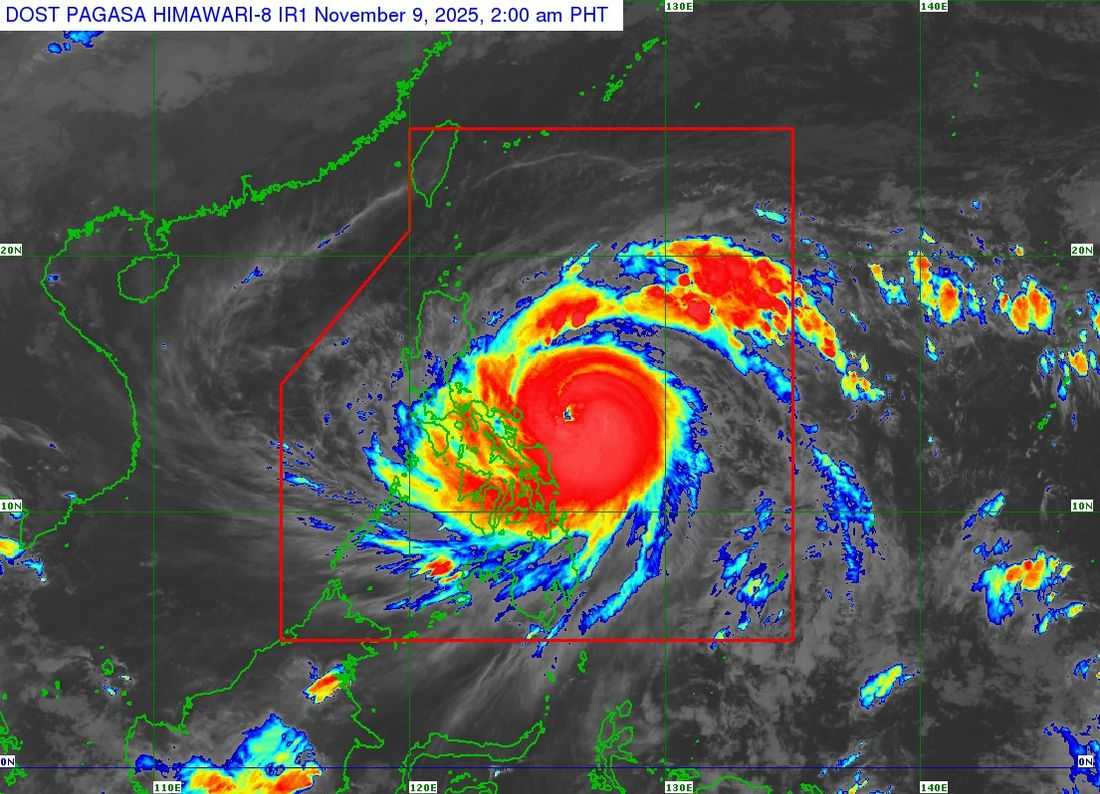
Typhoon Uwan (international name: Fung-Wong) continues to intensify while moving closer toward the Bicol Region, according to PAGASA’s 2:00 AM bulletin on Saturday, November 9.
As of 1:00 AM, the eye of Typhoon Uwan was located 370 km east of Virac, Catanduanes (13.8°N, 126.7°E). It now packs maximum sustained winds of 165 km/h near the center, gustiness of up to 205 km/h, and a central pressure of 945 hPa.
The typhoon is moving west northwestward at 35 km/h, with strong to typhoon-force winds extending outward up to 800 km from the center.
Tropical Cyclone Wind Signals (TCWS) in Effect
SIGNAL NO. 4
- Camarines Norte (southeastern portion: Mercedes, Basud, Daet, Talisay, Vinzons)
- Camarines Sur (eastern portion: Sagñay, Tigaon, Goa, Calabanga, Tinambac, Siruma, Lagonoy, Garchitorena, San Jose, Presentacion, Caramoan, Cabusao)
- Catanduanes
- Albay (eastern portion: Rapu-Rapu, Bacacay, Tabaco City, Malilipot, Malinao, Tiwi)
SIGNAL NO. 3
Luzon
- Central and southern Isabela
- Quirino, Aurora, Nueva Vizcaya (eastern and southern parts)
-
Nueva Ecija (eastern and central parts), Bulacan, eastern Pampanga, Metro Manila
-
Quezon (including Polillo Islands), Laguna, Rizal
-
Eastern Batangas and eastern Cavite
-
Rest of Camarines Norte, Camarines Sur, Albay, and Sorsogon
-
Ticao and Burias Islands
Visayas
-
Northern Samar
-
Northern Eastern Samar (Jipapad, Arteche, San Policarpo, Oras, Dolores, Maslog)
-
Northern Samar (Calbayog City, Gandara, Santa Margarita, Matuguinao)
SIGNAL NO. 2
Luzon
- Mainland Cagayan (including Babuyan Islands), the rest of Isabela and Nueva Vizcaya
-
Cordillera provinces: Apayao, Abra, Kalinga, Mountain Province, Ifugao, Benguet
-
Ilocos Region, Pangasinan, Tarlac, Zambales, Bataan
-
Rest of Cavite and Batangas, Marinduque, Romblon (northern and eastern towns)
-
Mindoro provinces (northern and central parts), Lubang Islands, mainland Masbate
Visayas
- Central Eastern Samar
- Central Samar
- Biliran
SIGNAL NO. 1
Luzon
- Batanes
- Rest of Romblon
- Mindoro provinces
- Calamian Islands
- Cuyo Islands
Visayas
- Rest of Samar and Eastern Samar
- Leyte
- Southern Leyte
- Bohol
- northern and central Cebu (including Bantayan and Camotes Islands)
- northern and central Negros Island, Guimaras, Iloilo, Capiz, Aklan, Antique
Mindanao
- Dinagat Islands
- Surigao del Norte
- northern Agusan del Norte
- northern Surigao del Sur
Other Hazards
-
Heavy Rainfall: PAGASA warns of heavy to intense rains, particularly over Bicol Region and Eastern Visayas.
-
Severe Winds: Areas under TCWS No. 4 and 3 may experience destructive winds in the next 12–18 hours.
-
Storm Surge: Life-threatening coastal flooding exceeding 3 meters possible in low-lying areas of Cagayan, Isabela, Ilocos, Central Luzon, Metro Manila, CALABARZON, and Bicol.
-
Gale Warning: Very rough to high seas up to 14 meters expected along eastern seaboards. All sea travel is risky.
PAGASA said Uwan is expected to pass close to Catanduanes this morning and may make landfall over Aurora by evening or early Monday. It could rapidly intensify into a super typhoon before landfall.
After crossing Northern Luzon, it is forecast to emerge over Lingayen Gulf or the coastal waters of Pangasinan or La Union by Monday morning.
Residents in high-risk areas are urged to prepare for possible evacuations and continuously monitor updates from PAGASA and local authorities.