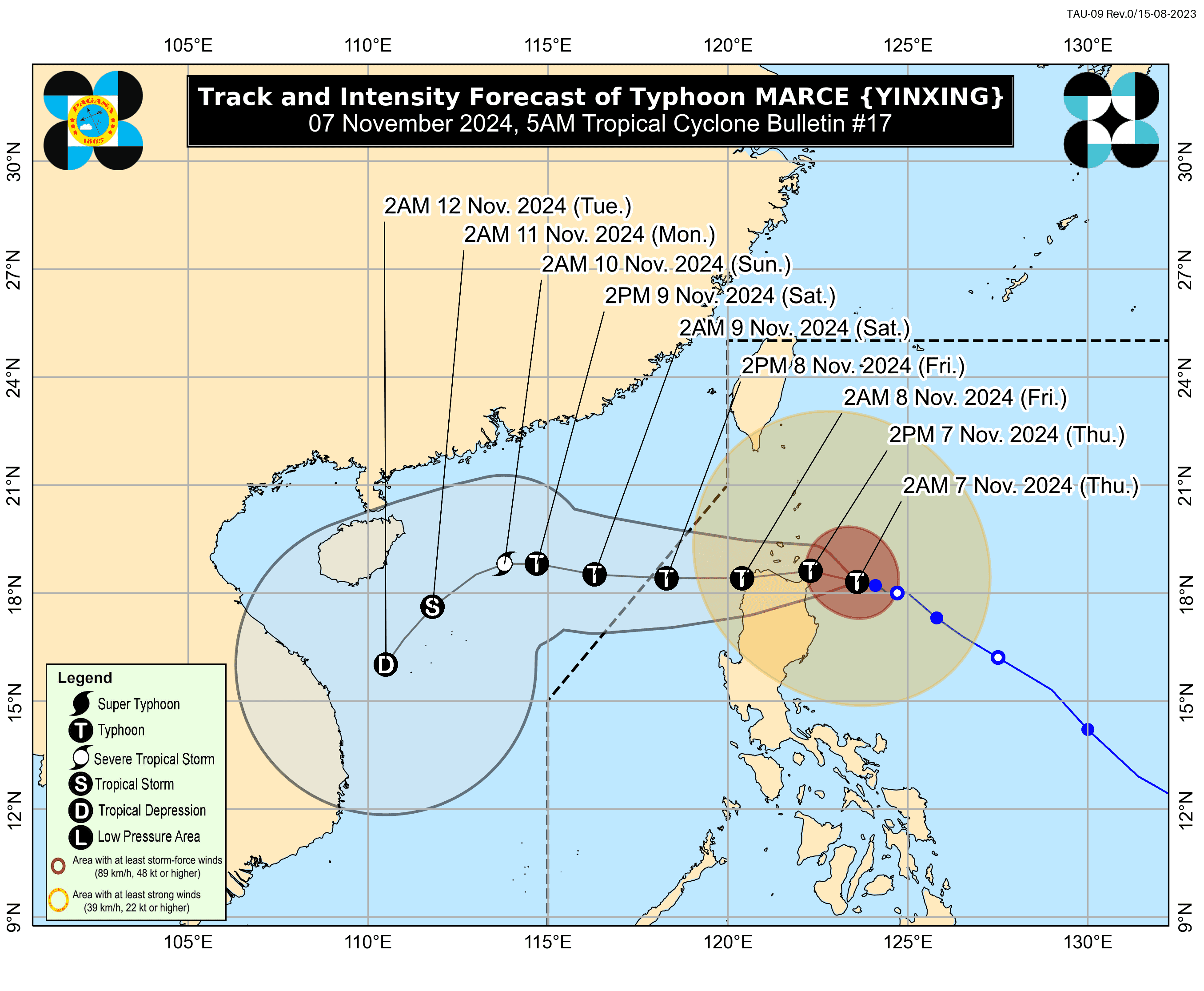

Typhoon Marce continues to pose a threat to Northern Mainland Cagayan, the Babuyan Islands, and the northeastern portion of Cagayan, where a Tropical Cyclone Warning Signal (TCWS) No. 4 has been raised.
According to PAGASA's 5 a.m. bulletin, the eye of Marce was located 200 km east of Aparri, Cagayan, packing maximum sustained winds of 155 km/h near the center and gusts of up to 190 km/h while moving west-northwestward at 15 km/h.
In addition to the areas under TCWS No. 4, Wind Signal No. 3 is raised in the following areas:
- the southern portion of Batanes (Mahatao, Uyugan, Basco, Ivana, Sabtang)
- the rest of Cagayan, the rest of Apayao
- Ilocos Norte
- the northern portion of Abra (Tineg)
Wind Signal No. 2 is raised over:
- The rest of Batanes
- the northern
- central portions of Isabela (San Pablo, Santa Maria, Divilacan, Tumauini, Maconacon, Cabagan, Santo Tomas, Quezon, Palanan, Ilagan City, Mallig, Delfin Albano, Quirino, San Mariano, Gamu, Roxas, Naguilian, Burgos, Reina Mercedes, Benito Soliven, Luna, Aurora, San Manuel, San Mateo, Alicia, Angadanan, City of Cauayan, Cabatuan)
- the rest of Abra
- Kalinga
- Mountain
- Province, the northern portion of Ifugao (Alfonso Lista, Aguinaldo, Mayoyao, Banaue, Hungduan)
- the northern portion of Benguet (Bakun, Mankayan)
- Ilocos Sur
- the northern portion of La Union (Sudipen, Bangar, Balaoan, Luna, Santol)
Wind Signal No. 1 is raised over:
- The rest of La Union
- Pangasinan
- the rest of Ifugao
- the rest of Benguet
- the rest of Isabela
- Quirino
- Nueva Vizcaya
- the northern and central portions of Aurora (Dilasag, Casiguran, Dinalungan, Dipaculao, Maria Aurora, Baler)
- the northern portion of Nueva Ecija (Carranglan)
- the northern portion of Zambales (Santa Cruz, Candelaria)
The state weather bureau warns the public about the general wind threat due to the tropical cyclone. Winds may be slightly stronger in coastal and upland areas exposed to winds, while weaker in areas sheltered from the prevailing wind direction.
Track and Intensity Outlook
Typhoon Marce is forecast to continue moving west-northwestward for the next 12 hours over the waters east of Cagayan before shifting generally westward from this afternoon until Saturday, November 9.
Based on the forecast track, Marce will make landfall over, or pass close to, the Babuyan Islands and/or the northern portions of mainland Cagayan, Ilocos Norte, and Apayao from this afternoon until early tomorrow morning, November 8.
Marce may exit the Philippine Area of Responsibility (PAR) by tomorrow evening. As the northeasterly wind flow intensifies, MARCE is expected to begin moving southwestward over the weekend.
The typhoon is expected to approach northern Cagayan at peak strength, though it may slightly weaken due to interaction with Luzon’s terrain. Nevertheless, Marce will remain a typhoon while within PAR, with continued weakening anticipated over the weekend due to the strong northeasterly winds.
