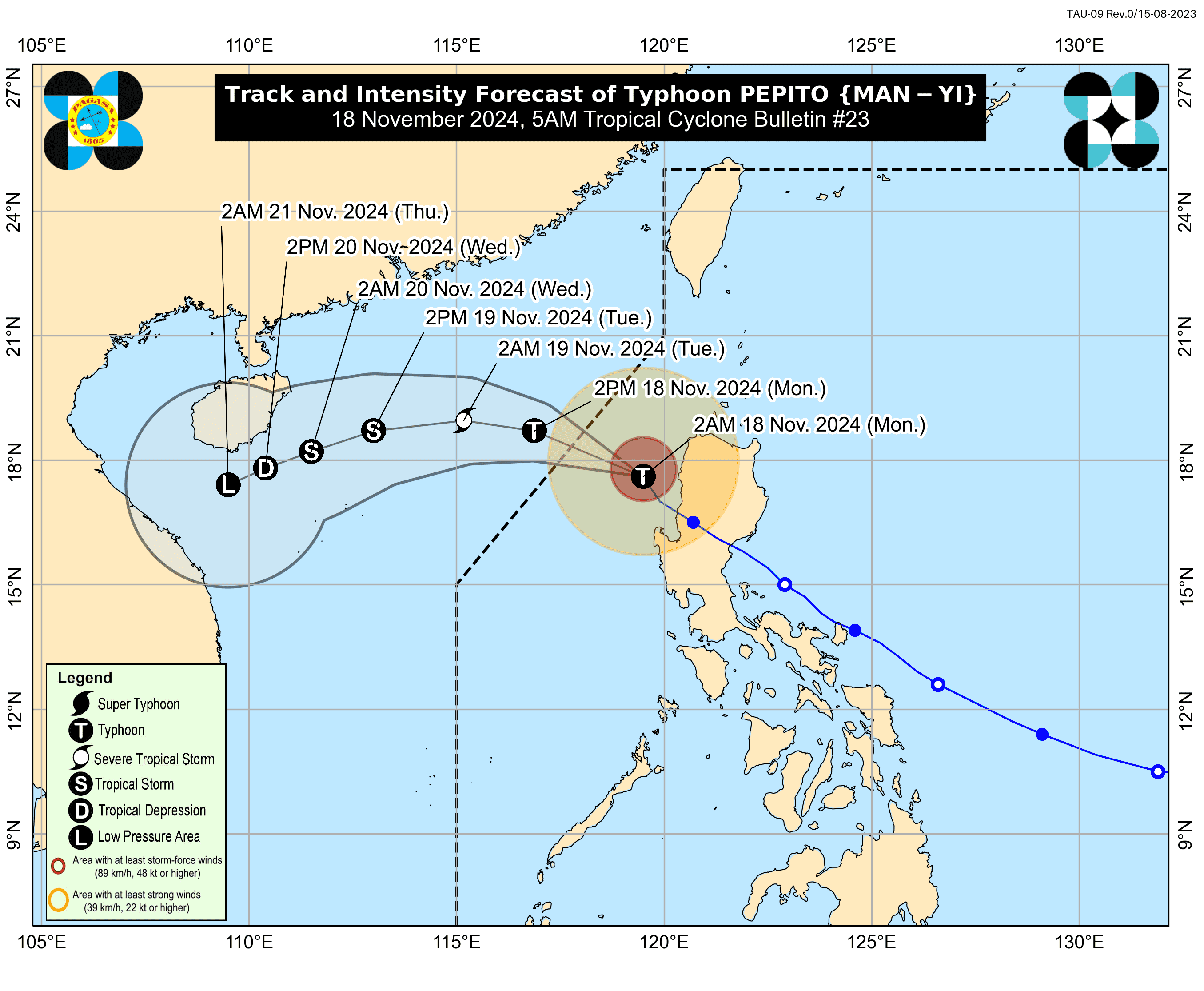

Typhoon Pepito continues its northwestward journey over the West Philippine Sea and is expected to exit the Philippine Area of Responsibility (PAR) by late Monday morning or noon. Despite this, Tropical Cyclone Wind Signals (TCWS) remain raised over various parts of Luzon.
According to PAGASA’s 5:00 AM bulletin, the eye of Pepito was located 45 km west of Sinait, Ilocos Sur, carrying maximum sustained winds of 130 km/h near the center and gustiness of up to 160 km/h, moving northwestward at 30 km/h.
Tropical Cyclone Wind Signals
Signal No. 3
Areas under TCWS No. 3 are likely to experience moderate to significant impacts due to storm-force winds. These areas include:
- The northern and western portions of Ilocos Sur (Gregorio del Pilar, Magsingal, San Esteban, Banayoyo, Burgos, City of Candon, Santa Lucia, Santiago, San Vicente, Santa Catalina, Lidlidda, Nagbukel, Sinait, Suyo, Sigay, San Ildefonso, Galimuyod, City of Vigan, San Emilio, Cabugao, Caoayan, San Juan, Santa, Bantay, Santo Domingo, Tagudin, Santa Cruz, Santa Maria, Narvacan, Salcedo)
- the northwestern portion of La Union (Luna, Bangar, Balaoan, Bacnotan), and the western portion of Abra (San Quintin, Langiden, Pidigan, Pilar)
Signal No. 2
Areas under TCWS No. 2 may experience minor to moderate impacts due to gale-force winds. These areas include:
- Ilocos Norte
- the rest of Ilocos Sur
- the rest of La Union
- Pangasinan
- the rest of Abra
- the western portion of Mountain Province (Besao, Tadian, Sagada, Bauko)
- Benguet, and the northern portion of Zambales (Santa Cruz, Candelaria)
Signal No. 1
Minimal to minor impacts are expected in areas under TCWS No. 1. These areas include:
- Apayao,
- Kalinga
- the rest of Mountain Province
- Ifugao
- the western portion of Cagayan (Lasam, Santo Niño, Solana, Enrile, Tuao, Piat, Rizal, Allacapan, Ballesteros, Abulug, Pamplona, Claveria, Santa Praxedes, Sanchez-Mira)
- Nueva Vizcaya
- the northern and central portions of Nueva Ecija (Bongabon, San Leonardo, Cabanatuan City, Santa Rosa, Jaen, Cuyapo, Talavera, Santo Domingo, Rizal, Zaragoza, Llanera, Guimba, Aliaga, Pantabangan, Science City of Muñoz, General Mamerto Natividad, Carranglan, Quezon, San Jose City, Lupao, Nampicuan, Talugtug, Licab, San Antonio, Palayan City, Laur)
- Tarlac
- the central portion of Zambales (Botolan, Iba, Cabangan, Palauig, Masinloc)
Coastal Hazards and Gale Warning
A Gale Warning remains hoisted over the seaboards of Northern Luzon and the western seaboard of Central Luzon. Mariners and small vessels are advised to avoid sea travel in these areas due to hazardous sea conditions.
Track and Intensity Outlook
Typhoon Pepito is forecast to continue moving northwestward today. Upon leaving PAR, the cyclone is expected to turn westward or west-southwestward by tomorrow, influenced by an incoming northeasterly wind surge.
As "Pepito" progresses over the West Philippine Sea, it will gradually weaken due to unfavorable environmental conditions.
The Weather State Bureau said the system is likely to degenerate into a remnant low by Wednesday evening (November 20) or early Thursday morning (November 21) near the southern coast of China.
