
Tropical storm Odette is not expected to be a super typhoon, according to the Philippine Atmospheric, Geophysical, and Astronomical Services Administration (PAGASA) on Tuesday, but it still urged caution as the weather disturbance is expected to escalate into a typhoon.
"Hindi naman po ito inaasahan maging isang super typhoon," PAGASA spokesperson Nicos Peñaranda told DZRH.
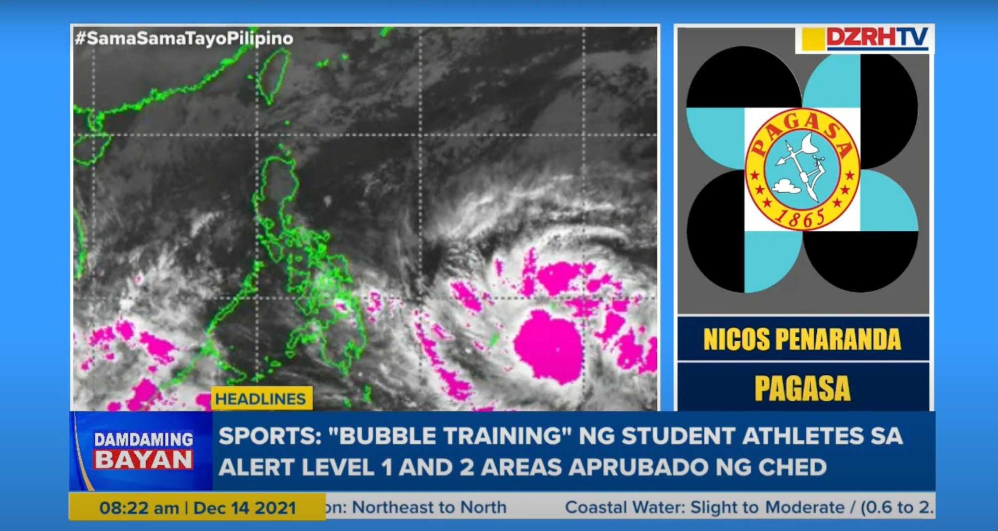
(We are not expecting it to become a super typhoon.)
However, the spokesperson warned that the tropical storm is expected to strengthen further and will become a severe tropical storm on Tuesday night, and later a typhoon before it hits the country.
Peñaranda said the typhoon currently has a gustiness reaching 105 kilometers per hour and is heading northwest at a speed of 30kph.
"Nagbabanta po itong bagyo dito sa general region po ng Eastern Visayas, 'yan po yung lalawigan ng Samar at Leyte at Caraga, so itong Surigao provinces at itong Agusan del Sur at ito pong area sa Northern Mindanao," he said.
(The storm is threatening the general region of Eastern Visayas, including the provinces of Samar and Leyte. It is also threatening Caraga, including the Surigao provinces and Agusan del Sur, as well as the area of Northern Mindanao.)
"Posible pong tamaan ng bagyo yung mga nabanggit na lugar sa Huwebes po ng hapon o gabi, 'yan po yung critical time, maaari pong mag-landfall," he added.
(The storm might hit the areas on Thursday afternoon or evening, that’s the critical time when the storm might landfall.)
According to Peñaranda, more rainfall is expected in the Visayas and Mindanao areas that are on the path of the storm, but because of its shape, even areas away from the center will experience strong rain and wind.
"Mas malawak po 'yung pag-ulan nito nung bagyo kesa sa hangin. Usually po, lalo na kapag dumadaan po sa Visayas-Mindanao area, mas compact po 'yung bagyo so ibig sabihin yung hangin maaaring dun lang po sa area kung saan po may tropical cyclone warning signal, pero po yung ulan po ay pwede pong makaapekto hanggang dito sa area po ng kabikulan."
(The storm’s rain will be wider than the wind. Usually, especially when storms are traversing the Visayas-Mindanao area, they are more compact meaning the wind may only be felt in areas where there is tropical cyclone warning signals, but the rain may go as far as the Bicol region.)
"'Yung buong mga lugar po na malayo sa sentro pwede pa rin pong makaranas ng mga malakas na ulan at may mga pagbugso ng malakas na hangin," he added.
(Places that are far from the center could still experience strong rain and strong gusts of wind.)
The storm is expected to cross the Visayas region and is expected to hit Palawan by Friday afternoon or evening. Despite not escalating to a super typhoon, Peñaranda cautioned the public from strong wind and rain that could still cause flash floods.