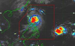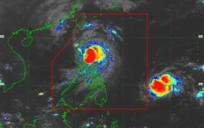

Typhoon Ofel, internationally known as Usagi, has intensified into a Super Typhoon, prompting the state weather bureau to raise Tropical Cyclone Wind Signal (TCWS) No. 5 over the northeastern portion of mainland Cagayan on Thursday morning.
In its 8 a.m. bulletin, the PAGASA said areas under TCWS No. 5 should expect very strong winds exceeding 185 kilometers per hour (kph).
Ofel is located 165 kilometers east-southeast of Tuguegarao City, Cagayan, packing maximum sustained winds of 185 kph and gusts reaching up to 230 kph. The super typhoon was moving northwest at 15 kph based on its latest forecast track.
Due to Ofel’s intensification, Pagasa raised TCWS No. 4 in the following parts of Northern Luzon:
- Southeastern portion of Babuyan Islands (Camiguin Island)
- Northern and eastern portions of mainland Cagayan (Santa Teresita,
- Ballesteros, Aparri, Camalaniugan, Buguey, Lal-Lo, Allacapan, Gattaran, Baggao, Peñablanca)
- Northeastern portion of Isabela (Maconacon, Divilacan, Palanan)
- These areas may experience strong winds between 118 kph and 184 kph, with residents advised to exercise caution as heavy damage to high-risk structures is possible.
Additionally, TCWS No. 3 has been raised over the following areas:
- Rest of Babuyan Islands
- Rest of Cagayan
- Northern, central
- southeastern portions of Isabela (San Pablo, Delfin Albano, Ilagan City, Tumauini, Cabagan, Santa Maria, Santo Tomas, San Mariano, Dinapigue)
Northern portion of Apayao (Flora, Santa Marcela, Luna, Pudtol, Calanasan, Kabugao) - Northern portion of Ilocos Norte (Pagudpud, Adams, Dumalneg)
Areas under TCWS No. 3 may expect winds ranging from 89 kph to 117 kph within the next 18 hours.
Meanwhile, TCWS No. 2, with expected winds from 62 kph to 88 kph, has been hoisted over the following areas:
- Batanes
- Western and southern portions of Isabela (Quezon, Quirino, Mallig, San Manuel, Aurora, Cabatuan, City of Cauayan, Benito Soliven, Naguilian, Gamu, Burgos, Reina Mercedes, Luna, Roxas, Angadanan, Alicia, San Guillermo, Echague, Jones, San Agustin, San Mateo, San Isidro)
- Northeastern portion of Quirino (Maddela)
- Rest of Apayao
- Kalinga
- Northeastern portion of Abra (Tineg, Lacub, Malibcong, Lagayan, San Juan, Lagangilang, Licuan-Baay, Daguioman)
- Eastern portion of Mountain Province (Paracelis)
- Eastern portion of Ifugao (Alfonso Lista)
- Rest of Ilocos Norte
- Northern portion of Aurora (Dilasag)
TCWS No. 1 is raised over the following areas:
- Rest of Isabela
- Rest of Quirino
- Nueva Vizcaya
- Rest of Mountain Province
- Rest of Ifugao
- Rest of Abra
- Northern portion of Benguet (Bokod, Mankayan, Kapangan, Atok, Kabayan, Kibungan, Bakun, Buguias, Tublay)
- Ilocos Sur
- Northern portion of La Union (Luna, Sudipen, Bangar, Santol, San Gabriel, Bagulin, Bacnotan, Balaoan, San Juan)
- Northern and central portions of Aurora (Casiguran, Dinalungan, Dipaculao, Maria Aurora, Baler, San Luis)
These areas are expected to experience strong winds from 39 kph to 61 kph, posing minimal to minor threats to life and property.
Based on Pagasa’s latest forecast track, Ofel is projected to continue moving northwest over the Philippine Sea and may make landfall along the eastern coast of Cagayan or northern Isabela by Thursday afternoon.
The typhoon is expected to emerge over the Babuyan Channel tonight, potentially making another landfall or passing close to the Babuyan Islands.
Pagasa warned that hazards on land and coastal waters may still affect areas outside the direct landfall zone and the forecast confidence cone.
The public is advised to stay vigilant for potential impacts, including strong winds, heavy rains, and possible storm surges.
A gale warning remains in effect for the northern and eastern seaboards of Northern Luzon and the eastern seaboard of Central Luzon due to Ofel’s intensification as a super typhoon.
