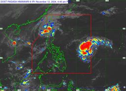

Severe Tropical Storm Nika has weakened further as it moves northwestward over the West Philippine Sea, according to PAGASA.
In PAGASA's 5 a.m. forecast, Nika was located 185 km west of Laoag City, Ilocos Norte, with maximum sustained winds of 95 km/h near the center and gustiness of up to 115 km/h. It is moving northeastward at 30 km/h.
As of 5:00 a.m., after entering the Philippine Area of Responsibility (PAR), Tropical Storm Ofel (#OfelPH) is moving west-northwestward at a speed of 25 km/h carrying maximum sustained winds of 75 km/h with gusts reaching up to 90 km/h. The storm may also track towards Northern Luzon.
Meanwhile, Tropical Cyclone Warning Signals (TCWS) remain raised in the following areas:
- Ilocos Norte
- the northern portion of Ilocos Sur (Lidlidda, City of Candon, Galimuyod, Banayoyo, Burgos, Santiago, Santa Maria, San Esteban, Nagbukel, Narvacan, Caoayan, Santa, Bantay, City of Vigan, Santa Catalina, San Vicente, San Ildefonso, Santo Domingo, Magsingal, Cabugao, San Juan, Sinait)
- the northern portion of Apayao (Kabugao, Pudtol, Luna, Santa Marcela, Calanasan, Flora)
- the northern and western portions of Abra (Tineg, Lagangilang, Bucay, Villaviciosa, Lagayan, San Juan, La Paz, Danglas, Pilar, San Isidro, Peñarrubia, Tayum, Dolores, Bangued, Pidigan, Langiden, San Quintin)
- the western portion of Babuyan Islands (Calayan Is., Dalupiri Is., Fuga Is.)
- the northwestern portion of mainland Cagayan (Abulug, Pamplona, Sanchez-Mira, Santa Praxedes, Claveria)
The state weather bureau reported that Nika will continue moving generally northwestward to westward over the West Philippine Sea and is expected to exit the Philippine Area of Responsibility within the next 12 hours.
It will continue to weaken in the coming days and may become a remnant low over the sea near southern China. Nonetheless, it will remain a severe tropical storm throughout its passage within the PAR region.
