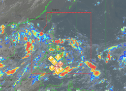

A low-pressure area (LPA) has been spotted inside the Philippine Area of Responsibility (PAR) and could soon intensify into a typhoon, PAGASA said on Wednesday, July 17.
At 3 a.m., PAGASA observed the LPA 200 kilometers East Northeast of Surigao City, Surigao del Norte.
"Hindi inaalis yung posibilidad na maging isang ganap na bagyo kaya continuous pa rin po yung monitoring natin dito sa binabantayan na sama ng panahon," said Rhea Torres from DOST-PAGASA during Magandang Umaga PIipinas.
According to the weather bureau, cloudy skies with scattered rain showers and thunderstorms should be expected in the Bicol Region, Eastern Visayas, Northern Mindanao, Caraga, Davao Region, Isabela, Aurora, Quezon, Marinduque, and Romblon due to the LPA.
Meanwhile, the rest of MIMAROPA, Visayas, and Mindanao will have cloudy skies with scattered rainshowers and thunderstorms caused by the Southwest Monsoon.
Metro Manila and the rest of CALABARZON will have partly cloudy to partly cloudy skies with isolated rain showers or thunderstorms due to the Southwest Monsoon.
Due to the localized thunderstorms, partly cloudy to cloudy skies with isolated rainshowers or thunderstorms will be experienced in the rest of Luzon.
"Wala po tayong gale warning sa ngayon peero inaasahan po natin yung mga katamtaman hanggang sa maalon na karagatan lalong alo na dito sa area ng Western Luzon. Sa mga may plano pong pumalaot as much as possible po ibayong pag-iingat lamang po at inaasahan po natin yung mga thunderstorms at mga malalakas na buhos ng ulan," Torres noted.