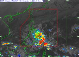

Tropical Cyclone Wind Signal (TCWS) No. 2 is hoisted in six Mindanao areas as tropical storm Kabayan maintained its strength while over Davao Oriental waters on Monday morning, Dec. 18, according to PAGASA's latest bulletin.
As of 4 AM, the state weather bureau spotted Kabayan over the coastal waters of Caraga, Davao Oriental, and is heading in a west northwestward direction at 15 kilometers per hour (kph) speed.
The tropical depression has 65 kph maximum sustained winds, 80 kph gusts, and 1002 hPa central pressure.
TCWS No. 2 is up in the following areas in Mindanao:
- Dinagat Islands
- Surigao del Norte including Siargao and Bucas Grande Islands
- Surigao del Sur
- The northern portion of Agusan del Norte (Kitcharao, Jabonga, Santiago, City of Cabadbaran, Remedios T. Romualdez, Tubay)
- The eastern portion of Agusan del Sur (Trento, Bunawan, San Francisco, Rosario, Prosperidad, City of Bayugan, Sibagat)
- The northern portion of Davao Oriental (Boston, Cateel)
The areas in Luzon that are under TCWS No.1 are as follows:
- The rest of Agusan del Norte
- The rest of Agusan del Sur
- The central portion of Davao Oriental (Baganga, Manay, Caraga, Tarragona, Lupon, Banaybanay)
- Davao de Oro
- Davao del Norte
- Davao City
- Camiguin
- Misamis Oriental
- Bukidnon
- Misamis Occidental
- Lanao del Norte
- Lanao del Sur
- The northern portion of Maguindanao del Norte (Buldon, Barira, Matanog, Parang, Sultan Kudarat, Sultan Mastura)
- The northern portion of Cotabato (Arakan, Carmen, Banisilan, Alamada, President Roxas, Kabacan, Matalam, Antipas, Magpet, Libungan, Pigkawayan)
- The northern and central portions of Zamboanga del Norte (Siayan, Sindangan, Jose Dalman, Manukan, Pres. Manuel A. Roxas, Sergio Osmeña Sr., Katipunan, Dipolog City, Polanco, Mutia, Piñan, Dapitan City, Sibutad, La Libertad, Rizal, Siocon, Baliguian, Gutalac, Labason, Kalawit, Tampilisan, Liloy, Salug, Godod, Bacungan)
- Zamboanga del Sur
- Zamboanga Sibugay
PAGASA raised a gale warning along the seaboard of Northern Luzon, the eastern and central seaboards of Visayas, and the eastern seaboards of Central Luzon, Southern Luzon, and Mindanao.
“Sea travel is risky for small seacraft (including all motor bancas of any type or tonnage). Mariners of these vessels are advised to remain in port or seek safe harbor,” it warned.
FORECAST
The state weather bureau forecasted that Kabayan “will likely make landfall as a tropical storm along the coast of Davao Oriental or southern Surigao del Sur this morning.”
Kabayan is also foreseen to be downgraded into a tropical depression and further into a low-pressure area “due to frictional effects associated with landfall.”
PAGASA, however, is not ruling out the possibility that Kabayan may re-develop again over the Sulu Sea.
“The tropical cyclone is forecast to make another landfall over central or southern Palawan as a tropical depression by tomorrow morning or afternoon, then emerge over the West Philippine Sea shortly thereafter,” the state weather bureau said.
“KABAYAN may pass near or over Kalayaan Islands between tomorrow evening and Wednesday morning,” it added.