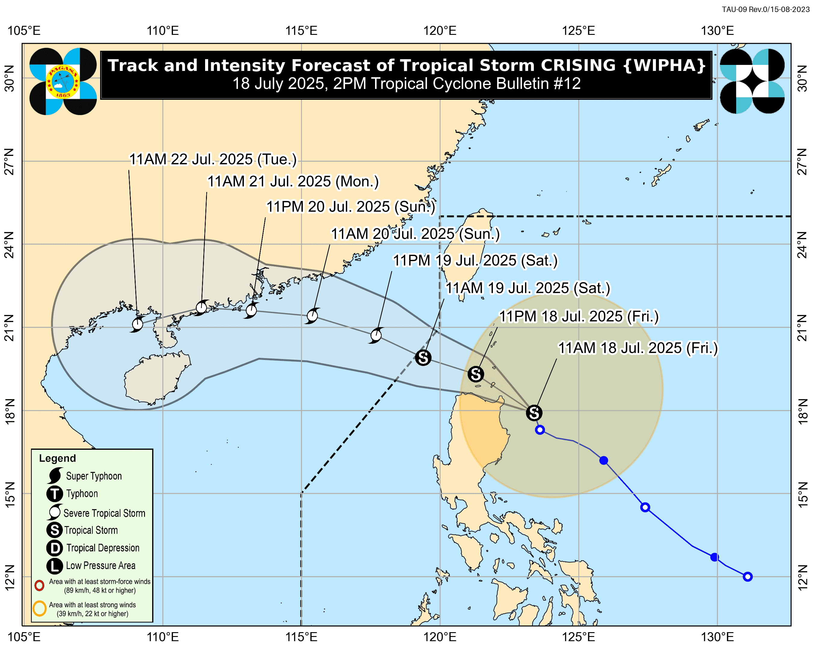
Tropical Storm #CrisingPH continues to intensify this afternoon as it continues to move northwest before it makes landfall over Cagayan-Babauyan Islands on Friday, July 18.
As of 2:00PM, PAGASA reported that the center of Crising was located 135 km East Northeast of Tuguegarao City, Cagayan, moving northwestward at 25 km/h, with maximum sustained winds of 75 km/h near the center and gustiness of up to 90 km/h.
Following this, some areas in Luzon are already raised to Tropical Cyclone Wind Signals:
Areas under Signal no. 2
- Batanes
- Cagayan
- Babuyan Islands
- Isabela
- Apayao
- Kalinga
- Northern and Central portion of Abra (Manabo, Pidigan, San Juan, Tayum, Langiden, Boliney, Sallapadan, Bucloc, Lagangilang, Danglas, La Paz, Licuan-Baay, Tineg, Malibcong, Peñarrubia, San Isidro, Daguioman, San Quintin, Dolores, Lagayan, Bangued, Bucay, Lacub)
Eastern portion of Mountain Province (Natonin, Paracelis) - Ilocos Norte
- Northern portion of Ilocos Sur (Cabugao, Sinait, Magsingal, San Juan, San Ildefonso, Santo Domingo, Bantay, San Vicente, Sant Catalina, Caoayan, City of Vigan, Santa)
Areas under Signal no. 1
- Quirino
- Nueva Vizcaya
- Mountain Province
- Ifugao
- Abra
- Benguet
- Ilocos Sur
- La Union
- Pangasinan (San Nicolas, Natividad, San Quintin, San Manuel, Tayug, Sison, San Fabian, Pozorrubio, Laoac, Binalonan, San Jacinto, Manaoag, Mangaldan, Dagupan City, Binmaley, Lingayen, Labrador, Sual, City of Alaminos, Bolinao, Anda, Bani, Agno, Burgos, Mabini, Dasol, Calasiao, Santa Barbara, Mapandan, Bugallon)
- Northern Portion of Aurora (Dilasag, Casiguran, Dinalungan, Dipaculao, Baler, Maria Aurora)
- Northeastern Portion of Nueva Ecija (Carranglan, Pantabangan)
Storm surge is expected within the next 24 hours over low-lying or exposed coastal localities of Batanes, Cagayan, including Babuyan Islands, Ilocos Norte, and Ilocos Sur.
The weather bureau also reminded all sea travel vessels that they are risky during this time, all mariners shall remain in port until winds and waves subside.
Cruising is expected to move west-northwestward across Extreme Northern Luzon before exiting the Philippine Area of Responsibility by tomorrow afternoon, July 19.
It is expected to reach the Severe Tropical Storm category by tomorrow morning or afternoon.