Five areas in Northern Luzon remained under Tropical Cyclone Wind Signal No. 3 as Severe Tropical Storm Florita maintained its strength after making a landfall in Isabela, Cagayan on Tuesday, August 23.
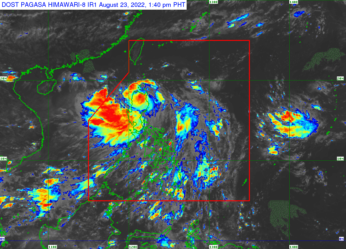
In its 2PM weather bulletin, PAGASA said the center of STS Florita was estimated in the vicinity of Acala, Cagayan with a maximum sustained winds of 110 km/h near the center, gustiness of up to 185 km/h, and central pressure of 985 hPa.
It is moving West Northwestward at 20 km/h and bears a strong to storm-force winds extend outwards up to 300 km from the center.
STS Florita made its landfall in the vicinity of Maconacon, Isabela at 10:30 AM today.
According to PAGASA, a storm-force winds are prevailing or expected within 18 hours in the following areas under TCWS No. 3:
- The northern portion of Ilocos Norte (Adams, Dumalneg, Bangui, Burgos, Pasuquin, Vintar, Pagudpud, Carasi, Bacarra, Piddig)
- Apayao
- the southern portion of Babuyan Islands (Camiguin Is., Fuga Is., Dalupiri Is.)
- mainland Cagayan
- the northeastern portion of Isabela (Palanan, Divilacan, Maconacon, San Pablo, Tumauini, Cabagan, Santa Maria, Santo Tomas, Delfin Albano, Ilagan City, San Mariano)
Gale-force winds are prevailing or expected within 24 hours in these areas under TCWS No. 2:
- The rest of Babuyan Islands
- the rest of Isabela
- Quirino
- the northern and eastern portion of Nueva Vizcaya (Quezon, Diadi, Bagabag, Villaverde, Solano, Kasibu)
- Abra
- Kalinga
- Mountain Province
- Ifugao
- the northern portion of Benguet (Buguias, Bakun, Mankayan, Kibungan)
- the rest of Ilocos Norte
- Ilocos Sur
- the northern portion of Aurora (Dilasag, Casiguran, Dinalungan, Dipaculao)
Meanwhile, the following areas under TCWS No. 1 are experiencing strong winds (strong breeze to near gale strength)
- Batanes
- the rest of Nueva Vizcaya
- the rest of Benguet
- La Union
- the eastern portion of Pangasinan (Santo Tomas, Villasis, Mapandan, Mangaldan, San Fabian, San Jacinto, Manaoag, City of Urdaneta, Rosales, Balungao, Umingan, San Quintin, Natividad, San Nicolas, Tayug, Santa Maria, Asingan, San Manuel, Binalonan, Sison, Pozorrubio, Laoac, Dagupan City)
- the northeastern portion of Tarlac (San Manuel, Anao),
- Nueva Ecija
- the rest of Aurora
PAGASA said heavy to intense with at times torrential rains over Cagayan including Babuyan Islands, Isabela, Cordillera Administrative Region, Ilocos Region, Zambales, and Bataan.
Moderate to heavy with at times intense rains, meanwhile, will be over the northern portion of Aurora, Tarlac, Pampanga, Bulacan, Metro Manila, Cavite, Rizal, and the rest of Cagayan Valley.
PAGASA said scattered to widespread flooding (including flash floods) and rain-induced landslides are expected especially in areas that are highly or very highly susceptible to these hazard as identified in hazard maps, and in localities with significant antecedent rainfall.
"Severe Tropical Storm Florita will continue moving generally northwestward or west northwestward and is forecast to traverse the mainland Cagayan and Apayao," the state weather bureau said.
It added that Florita will emerge over Babuyan Islands tonight and may exit the Philippine Area of Responsibility (PAR) by Wednesday morning.